
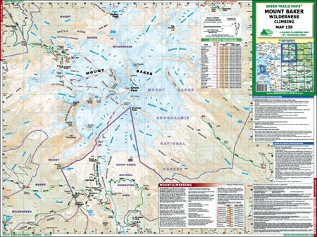

If climbing Mt. Baker is on your tick-list the Green Trails Mt. Baker Climbing Map is a must have essential.
Printed on waterproof tear resistant paper, this map is plenty durable to stand up to use many times on the mountain. Designed with help from AAI guides, you're sure to get accurate climbing route details for your summit attempt. Waypoints for important locations such as campsites, hazards and key route points are marked on the map. Pre-load them into a GPS before you go, or when on the mountain.
One side of the map is scaled at 1:63,360 which allows it to be used for hiking trails around the Mt. Baker/Mt. Shuksan/Baker Lake area, and along highway 542. The other side is scaled at 1:24,000 and shows all of Mt. Baker on one map for use when climbing. Baker's 3 most popular routes are highlighted for easier route-finding/navigation; the Coleman-Deming, the North Ridge and the Easton.